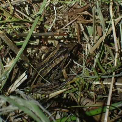
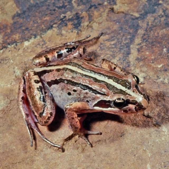
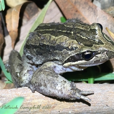
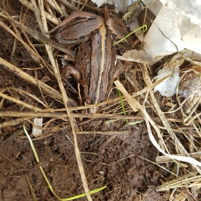
Brown-striped Frog, also known as Striped Marsh Frog, is a large wetland-dwelling frog and ferocious hunter. This frog eats almost any animal smaller than itself, including small frogs.
Current conservation status: Uncommon in ACT. Found in localised pockets, mostly in northern ACT.
Family: Myobatrachidae
Appearance: This species resembles Limnodynastis tasmaniensis, but can be distinguished by the pattern of dark and light-brown stripes on the back. It has a slightly raised pale stripe running along the upper jaw edge from the snout, and below the eyes to the forelimbs. This stripe is accentuated by the presence of a dark stripe along the side of the head that passes through the eyes.
Length: up to 70mm
Breeding: Breeding commences in late spring but most calling and breeding occurs in early summer (October to February).
Habitat: Found mainly in low-lying open country that has a good cover of perennial tussock grasses, including lowland rivers, creeks, swamps, farm dams and lakes.
Distribution: Generally uncommon in the Canberra region and very uncommon in coastal regions of NSW.
Biology: A single floating foam nest is made during egg laying. The tadpoles are dark-coloured and graze actively on the surface of submerged vegetation and detritus. They are most commonly found in and near shallow marshes and reed beds at the edges of the urban lakes and creeks. Small populations still occur in some low-lying areas that were formerly wet tussock grasslands in the region.
Call: A distinctive single "pop", "toc"or "splut" that is monotonously repeated once every few seconds. In a chorus, the calls of many individuals combine into a more rapid continuous popping or spluttering sound.
Brown-striped Frog, also known as Striped Marsh Frog, is a large wetland-dwelling frog and voracious hunter, this frog eats almost any animal smaller than itself, including small frogs. Adult length: 45-75mm.
Current conservation status: Uncommon in ACT.
Distribution: Found in localised pockets, mostly found in northern ACT.
Limnodynastes peronii is listed in the following regions:
Canberra & Southern Tablelands | Southern Highlands | South Coast | Greater Sydney | Hunter Region | New South Wales North Coast
Maps
ANBG ANU Banks Precinct ANU Daley Precinct ANU Dickson Precinct ANU Ellery Precinct ANU Garran Precinct ANU Kingsley Precinct Aranda Bushland Australian National University Banksia Street Wetland Corridor Barunguba (Montague) Island Bega River Bioblitz Benandarah State Forest Black Flat at Corrowong Black Mountain Bournda Environment Education Centre Bournda National Park Bournda Nature Reserve Broulee Moruya Nature Observation Area Bruce Ponds Bruce Ridge Bruce Ridge to Gossan Hill Brundee Swamp Nature Reserve Budjan Galindji (Franklin Grassland) Reserve Bugong National Park Bundanoon Burradoo CA0779 Callum Brae Canberra City Farm Central Molonglo City Renewal Authority Area Commonwealth & Kings Parks Cooleman Ridge Coombs Ponds Crace Grasslands Dangelong Nature Reserve Depot Beach Bushcare Dickson Wetland Dickson Wetland Corridor Dunlop Grasslands Eurobodalla National Park Fadden Hills Pond Farrer Ridge Flea Bog Flat, Bruce Four Winds Bioblitz Reference Sites Fyshwick Sewerage Treatment Plant Gang Gang at Yass River Giralang Wetlands Goulburn Mulwaree Council Gungahlin Pond Illilanga & Baroona Isaacs Ridge Isaacs Ridge and Nearby Isabella Pond Jarramlee Pond Jarramlee-West MacGregor Grasslands Jerrabomberra Grassland Jerrabomberra Wetlands Kama Lake Burley Griffin Central/East Lake Ginninderra Lower Cotter Catchment Lyneham Wetland Mawson Ponds McKellar Wetlands Molonglo River Reserve Mongarlowe River Mount Ainslie Mount Ainslie to Black Mountain Mount Majura Mount Mugga Mugga Mulanggari Grasslands Mulligans Flat Murramarang National Park Nadgee Nature Reserve Namadgi National Park National Arboretum Forests Nunnock Swamp O'Connor Ridge to Gungahlin Grasslands Panboola Point Hut Pond Seven Mile Beach National Park South East Forest National Park Stranger Pond Sullivans Creek, Acton Sullivans Creek, Lyneham North Sullivans Creek, Lyneham South Sullivans Creek, O'Connor Sullivans Creek, Turner The Pinnacle The Ridgeway Reserve Thirlmere Lakes National Park Tidbinbilla Nature Reserve Tuggeranong Creek to Monash Grassland Tuggeranong Homestead A.C.T. Ulladulla - Millards Creek Umbagong District Park Wallum Watson Green Space Watson Woodlands West Belconnen Pond West Goulburn Bushland Reserve Wingecarribee Local Government Area Wollondilly Local Government Area Yerrabi PondSurvey points
AMH100: Anke Maria's Pond ANB100: ANBG pond ANU012: Dickson/Clunies Ross DAM ANU018: Sullivans Creek, downstream of Burgmann College. ANU019: Sullivans Ck Daley Rd/Ward Rd ANU020: Sullivans Creek Stepping Stones, Adjacent to Building 46. ANU021: Sullivans Ck Near BLD 45 ANU022: Creek, upstream of University Ave bridge ANU023: Sullivans Creek, downstream of Barry Drive GPT ANU041: Constructed swale ANU042: Constructed pond, adjacent to Dickson Rd Carpark, Acton ANU22B: Sullivans Creek, upstream of University Ave bridge ARA200: Bindubi St Gate BAR050: Barracks Ck Dam 2 BAR200: Doyle Reserve N BAR201: Doyle Reserve S BIL100: Billabong Pond, Watson BMT100: Black Mtn SW Dam BON200: Stranger Pond Bonython at BBQ shelter BRU100: AIS bike path drain BSW001: Banksia St Wetland BUN200: Elmslea Estate Pond, Bungendore CAV100: Caves Quarry Dam CBR002: Callum Brae 2 CBR003: Callum Brae 3 CBR004: Callum Brae 4 CEQ100: Equestrian Park 1 CFR100: Molonglo River on Reynolds property, near Balcombe Hill CFR200: Hodgman's Large Dam CFR300: Molonglo off Capt Flat Rd CGH050: Hospital Ck 1, Namadgi CHC100: Calvary Hospital Drain3 , Bruce CHC300: Calvary Hospital Pond CMM200: Gordon Stormwater Pond CMW500: Weston Creek Sediment Pond- former cross pollutant trap COB013: Cooma Back Ck @ Coolamatong CON002: Condor Ck Near Pines COO002: Dam at Koskinan Property COO100: Kathner St Dam CRA300: Wells Stn/Gungahlin Dr CRW001: Crace Wetland Pond 1 CTP450: Murrays Corner DGP001: Dunlop Grasslands Dam DIW100: Dickson Wetland FAD100: Fadden Hills FAR002: Farrer Ridge 2 FBM200: Black Mtn Storage Yard FBM300: Black Mtn Path FBM400: Black Mtn Belconnen Way FBM500: Black Mtn SW FBP001: W-Belconnen Pond FGB001: Hollows Crescent FGB002: Refshauge Crescent FGC006: Ginninderra Creek at Spain Place footbridge, Evatt FGC007: Ginninderra Creek, at Ginninderra Drive, Flynn FGC009: Jarramlee Pond FGC010: Lake G/College Ck FGC029: Fassifern Pond FGC030: Gooromon Ponds Ck FGC090: Ginninderra Ck, Macgregor FGC091: Crago Place Billabong FGD005: John Knight Park FGD010: Lake G West FGD020: O'Connor Ridge Dam FGD030: AIS, Drain near bike path FGD035: AIS Wetland FGG010: Giralang Pond FGW100: Umbagong Eastern Boardwalk FGW150: Umbagong Park, Latham Western Boardwalk Bog FGW200: Latham, Herron Creek FLE100: Gungahin, Flemington Road Dam FMC020: QBN River @ Barracks Flat FMC040: Buttles Ck 1 QBN FMC045: Buttles Ck 2 QBN FMC200: Mt Majura 1 Lower FMC210: Mt Majura 2 Upper FMC220: Mt Majura 3 Jukes FMC230: Mt Majura 4 Saddle FMD010: Hacket Water Tank 1 FMF320: JR Hope Park FMW010: David St Wetland FMW020: Dryandra St Wetland, Oconnor FOR001: Forde Wetland FOR002: Forde Pond FRA200: Edlington St Pond, Fraser FRA201: Halls Ck, Fraser FTB010: Bogong Ck FTD160: Tidbinbilla Nature Reserve, Barbeque Swamp FTD165: TNR Bottom Dam FTD220: TNR Sheedys Picnic Area FTP100: Isabella Pond FTT010: Tuggeranong Homestead GAR200: Garuwanga site 2, hooded robin dam, Nimmatabel GAR400: Garuwanga site 4, Winnifred Creek, Nimatabel GIN007: Ginninderra Ck @ Barton Hwy GIN008: Ginninderra Creek downstream from GIN007 GIN009: Ginninderra Ck @ dam wall GIN024: Umbagong Stepping Stones GUN001: Gungahlin Pond GUN100: Valley Ponds W/Scout Hall GUN110: Valley Ponds East GUN200: Burgman Anglican School Pond GUN300: Haystack Dam, gungahlin HAL001: Halls Creek @ Showground HMD000: O'Malley Pond HOS001: 175 Pollack Rd Hoskinstown Angus Adair's Farm ISA100: Long Gully Rd/Mugga Lane JBT001: Melba Wetland @ BMX JER020: Jerrabomberra Ck Lanyon Dr JER300: Dairy Ck/Mill Ck JER310: Jerrabomberra Dairy Creek - Mill Creek JER320: Jerrabomberra Dairy Creek - Mill Creek JER500: JWs - Kellys @ Bittern Birdhide JER510: JWs - East of Billabong JER515: JWs - end of billabong, WL#21 JER520: JWs - Billabong JER540: JWs - Btw Billabong and Estate JER550: JWs - Jerra Ck @ Board Walk JER560: JWs - Fulica Hide JER570: JWs - Kellys Swamp South JER580: JWs - Silt trap, inflow, WL#18 JER630: JWs - Paleo channel area, WL#3 JER640: JWs - Paleo Channel, WL#1 JER650: JWs - Peninsula Split, WL#16 JER660: JWs - Sewer Pond (near pump station) JER670: JWs - Sewer Pond permanent water JER700: JWs - Eyrie St Wetland KAL300: Diamantina Cresent Drainage Channel KAM200: Kama Dam 2 KIP001: Kippax Ck, Holt LWP100: Little Whiskers Rd Pond LWR100: Little Whiskers Rd River LWR200: Briar Sharrow Bridge LYW010: Lyneham Wetland MCW001: McKellar Wetland 1 MCW002: McKellar Wetland 2 MCW010: Frog highway, drainage line between 2 McKellar wetlands MFL002: 2nd Pond from Entrance MFL003: Shearing Shed Dam MFL005: 250m N of Woolshed MFL011: Largest Dam South MFL012: Near Bird Site 8 MFL013: SE Dam Near Bird Site 7 MFL017: Eastern Reserve 2 MFL023: Daisy Gate Dam MGC100: Murrumbidgee Golf Course MIR100: Amaroo Ginninderra Ck MIT100: Gungahlin Cemetery MOL150: Molonglo River, at Molonglo River Park MOL600: Creek near Tannery Beard MOL602: Beard Ck 1 MOL605: Oaks Estate Rd Causeway MUR100: Top dam on Lewis property, Gang Gang, Murrumbateman MUR200: Chain of ponds on Lewis property Gang Gang, Murrumbateman MUR250: Lake Kevin MYA100: Yarralumla Ck, Curtin Oval NAA100: Naas River causeway, Caloola Farm NAD034: Cork Oak Dam Lot 34 NAD036: Larch Dam Forest 36 NBP001: Nursery Inlet S pond NBP002: Nursery Inlet N Pond NBP003: Royal Golf Club ORR100: Orroral Valley Rock waterfall Stream ORR200: Orroral Valley Nursery Swamp Trail. OSR005: Dam 5 Hidden Dam OSR006: Dam 6 Pambula Preschool PAR100: Parsons Property, Molonglo River at house. PAR200: Parsons Property, Molonglo River Site 2 PIA200: Piallago Brook PIN100: Pinnacle Dam, Hawker PLM100: Laver Farm Dam 1 PLM200: Laver Farm Dam 2 PLM300: Laver Farm, Gully Dam PLM310: Laver Farm, Gully Dam - 100m upstream from PLM300 PLM400: Laver Farm Dam 3 (on adjacent property) Point 25 Point 4761 QBN010: Lonergan Drive, Greenleigh QBN011: Mountain Rd Drainage Ditch QBN465: QBN River Downstr @ Dane St QBN466: QBN River Upstr @ Dane St RCD001: Rose Cottage Paddock 8 RCD002: Rose Cottage Paddock 7 SFF100: Stromlo Forest Dam, Coombs STP100: Strathnairn Main Pond TAL001: Tallulah Dam 1 TOR100: Orroral River Campsite TRA100: Travica property UHD015: Urila Home Dam UMB100: Ginninderra Crk, Umbagong Carpark WAM001: Wamboin Community Centre Dam YRR100: Yass River ReservePlaces
Blaxlands Creek, NSW Braidwood, NSW Bruce, ACT Charleys Forest, NSW Goulburn, NSW Kaleen, ACT Kingston, ACT Mawson, ACT Mount Kembla, NSW Shark Creek, NSW